

Unlock the Subsurface with High-Resolution Borehole Imaging
Borehole Image Processing and Interpretation
Master the principles, processing, and interpretation of borehole images to enhance exploration and reservoir decisions.


Borehole Image Processing and Interpretation
Have Questions ?
Borehole Image Processing and Interpretation - EL-BHI-PEA
| Code | Duration | Currency | Fee Per Person |
|---|---|---|---|
| EL-BHI-PEA |
15 Hours
|
USD
|
500
|
This is a self-paced, on-demand e-learning course. Upon enrollment, all course videos and materials will be delivered to your email within 12 hours. A certificate will be issued upon successful completion of the required quizzes and assignments.
Boost your team's skills and your budget! Enjoy group discounts for collaborative learning. Send an inquiry to info@peassociations.com.
Borehole Image Processing and Interpretation
This self-paced course provides a complete foundation in borehole image processing and interpretation, equipping energy professionals with the knowledge to analyze fractures, faults, and reservoir features with confidence.
Description
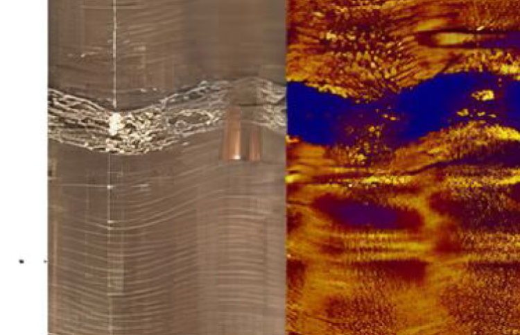
Borehole images are one of the most powerful tools available for understanding the subsurface. They provide high-resolution measurements that reveal fractures, faults, sedimentary structures, and reservoir quality indicators. This course offers a structured pathway to learn the principles behind borehole imaging, the processing workflow, and advanced interpretation methods. Participants will explore both wireline and logging-while-drilling image tools, master quality control parameters, and integrate images with petrophysical and geological data. Through exposure to diverse applications — from structural analysis and dip computation to facies classification and reservoir modeling — learners will gain the competence to extract actionable insights from borehole image datasets.
In today’s exploration and reservoir development environments, accurate subsurface interpretation is critical to reduce uncertainty and maximize hydrocarbon recovery. Borehole images provide a window into the geological record, capturing the fine details that conventional logs often miss. This course empowers professionals to fully leverage borehole imaging technology from data acquisition principles to structural and stratigraphic interpretation ensuring better decisions in well planning, field development, and reservoir management.
By completing this course, participants will be able to:
• Explain the theory and physical principles of borehole imaging.
• Differentiate between wireline (WL) and logging-while-drilling (LWD) image tools.
• Perform dip computation and apply dip representation methods.
• Conduct image quality control and parameter checks.
• Interpret faults, fractures, bedding, and sedimentary structures.
• Recognize and classify porosity, facies, and diagenetic features.
• Integrate borehole images with other petrophysical and geological datasets.
• Apply borehole image interpretation to build more robust reservoir models.
• Enhanced reservoir characterization and reduced exploration risk.
• Better integration of geological and engineering data for development planning.
• Improved wellbore stability monitoring and operational efficiency.
• Stronger decision-making support for exploration, appraisal, and field development projects.
• Confidently interpret borehole images across clastic and carbonate settings.
• Identify fractures, faults, and stratigraphic features that influence production.
• Improve wellbore stability assessments and select optimal core or pressure points.
• Strengthen career growth by mastering a high-demand subsurface skillset.
• Reservoir, wellsite, and operations geologists
• Geoscientists and petrophysicists
• Petroleum engineers working in exploration and field development
• Mud loggers and professionals involved in formation evaluation
• Anyone seeking to strengthen their expertise in borehole image interpretation
• Borehole Image Fundamentals
• Theory and physical principles of image logging
• Types of borehole image tools (WL and LWD)
• Static and dynamic image modes
• Image Processing and Quality Control
• Normalization and image generation
• Logging parameters and QC methods
• Interactive dip picking techniques
• Structural and Geological Interpretation
• Dip computation and dip representation
• Fault detection and structural analysis
• Borehole breakout and drilling-induced fractures
• Identification and classification of natural fractures
• Sedimentology and Stratigraphy
• Cross-bedding and paleocurrent analysis
• Secondary porosity detection
• Facies classification and interpretation
• Recognition of sedimentary structures
• Data Integration and Applications
• Combining borehole images with petrophysical logs
• Selecting core and pressure points
• Integrating geological and engineering data
• Case studies across clastic and carbonate reservoirs
• Reservoir Modeling Support
• Linking borehole images to reservoir models
• Predicting reservoir behavior and performance
On successful completion of this training course, PEA Certificate will be awarded to the delegates
This course has been meticulously developed by a seasoned PEA expert renowned in the oil and gas industry. With extensive hands-on experience and a proven track record in delivering innovative solutions, our trainer brings a wealth of technical expertise, deep industry insight, and a commitment to excellence. Learners can trust that they are gaining knowledge from a leading authority whose dedication to professional development ensures you receive only the highest-quality training to elevate your skills and career prospects.