

Transform Seismic Data into Actionable Insights for Hydrocarbon Exploration
Seismic Interpretation: Identifying and Mapping Hydrocarbon Accumulations
Training in seismic interpretation, fault mapping, stratigraphy, and hydrocarbon accumulation assessment


Seismic Interpretation: Identifying and Mapping Hydrocarbon Accumulations
Have Questions ?
Seismic Interpretation: Identifying and Mapping Hydrocarbon Accumulations - EL-SI-PEA
| Code | Duration | Currency | Fee Per Person |
|---|---|---|---|
| EL-SI-PEA |
20 Hours
|
USD
|
500
|
This is a self-paced, on-demand e-learning course. Upon enrollment, all course videos and materials will be delivered to your email within 12 hours. A certificate will be issued upon successful completion of the required quizzes and assignments.
Boost your team's skills and your budget! Enjoy group discounts for collaborative learning. Send an inquiry to info@peassociations.com.
Seismic Interpretation
This self-paced course equips professionals with the skills to interpret seismic data, map structural and stratigraphic features, and evaluate hydrocarbon accumulations with confidence.
Description
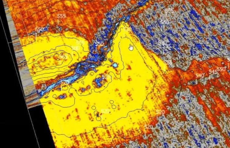
Seismic interpretation is one of the most critical skills in hydrocarbon exploration and development. This Course offers a structured, application-oriented approach to reading seismic data, building structural and stratigraphic models, and identifying hydrocarbon accumulations. Participants will gain experience in data acquisition, processing, interpretation, and risk assessment, supported by case studies. Delivered in a flexible e-learning format, this course provides geoscientists and petroleum engineers with the skills to transform seismic data into actionable exploration and development insights.
The ability to accurately interpret seismic data directly impacts exploration success and investment decisions in oil and gas projects. From fault mapping to volumetric calculations, participants will develop the technical confidence to identify opportunities, assess risks, and contribute effectively to exploration and development projects.
By completing this course, participants will be able to:
• Understand seismic data acquisition, processing, and calibration methods.
• Interpret 2D and 3D seismic datasets using software tools.
• Map faults, horizons, and structural features with accuracy.
• Identify seismic facies and depositional environments.
• Build structural and stratigraphic models, including Wheeler diagrams.
• Map and quantify hydrocarbon accumulations.
• Apply risk assessment methods for exploration and resource evaluation.
• Improved exploration success through more accurate seismic interpretation.
• Reduced risks in resource evaluation and investment decisions.
• Enhanced technical capabilities of geoscience and exploration teams.
• Stronger integration of seismic interpretation with petroleum system analysis.
• Gain confidence in interpreting seismic datasets for exploration projects.
• Develop practical skills in mapping hydrocarbon prospects.
• Enhance knowledge of seismic stratigraphy and petroleum system elements.
• Strengthen career potential in geoscience, exploration, and reservoir development.
This course is ideal for:
• Geologists and geology engineers
• Geophysicists
• Exploration and development geoscientists
• Petroleum engineers involved in exploration projects
• Reservoir engineers and asset evaluation teams
• Graduate students and early-career professionals in geoscience disciplines
Introduction and Foundations
-
History of seismic studies
-
Seismic methods and wave propagation
-
Data acquisition: land and marine techniques
-
Other geophysical methods (gravimetry, magnetics, electromagnetics)
Seismic Data Processing
-
Pre-stack and post-stack processing
-
Seismic migration and velocity models
-
Calibration methods (velocity surveys, sonic logs, synthetic seismograms, VSP)
2D and 3D Seismic Interpretation
-
Data parameters, visualization, and polarity
-
Interpretation techniques: slicing, horizons, and fluid contacts
-
Quantitative interpretation: acoustic impedance, inversion, AVO, RMS amplitude, spectral decomposition
Fault and Structural Interpretation
-
Fault identification and mapping in 2D and 3D
-
Structural styles: rift basins, compressional domains, salt tectonics, strike-slip settings
-
Building fault planes and structural models
Stratigraphic Interpretation
-
Horizon interpretation and attributes
-
Seismic facies in carbonate and siliciclastic systems
-
Unconformities, stratal terminations, depositional environments
-
Advanced sequence stratigraphy and Wheeler diagrams
Petroleum System and Hydrocarbon Accumulations
-
Reservoir, seal, source rock, trap, timing, and migration
-
Mapping hydrocarbon accumulations: structural, stratigraphic, and mixed traps
-
Volumetric calculations (leads, prospects, reserves, resources; P10, P50, P90)
-
Risk assessment and integration of geological risk into economic evaluations
On successful completion of this training course, PEA Certificate will be awarded to the delegates
This course has been meticulously developed by a seasoned PEA expert renowned in the oil and gas industry. With extensive hands-on experience and a proven track record in delivering innovative solutions, our trainer brings a wealth of technical expertise, deep industry insight, and a commitment to excellence. Learners can trust that they are gaining knowledge from a leading authority whose dedication to professional development ensures you receive only the highest-quality training to elevate your skills and career prospects.